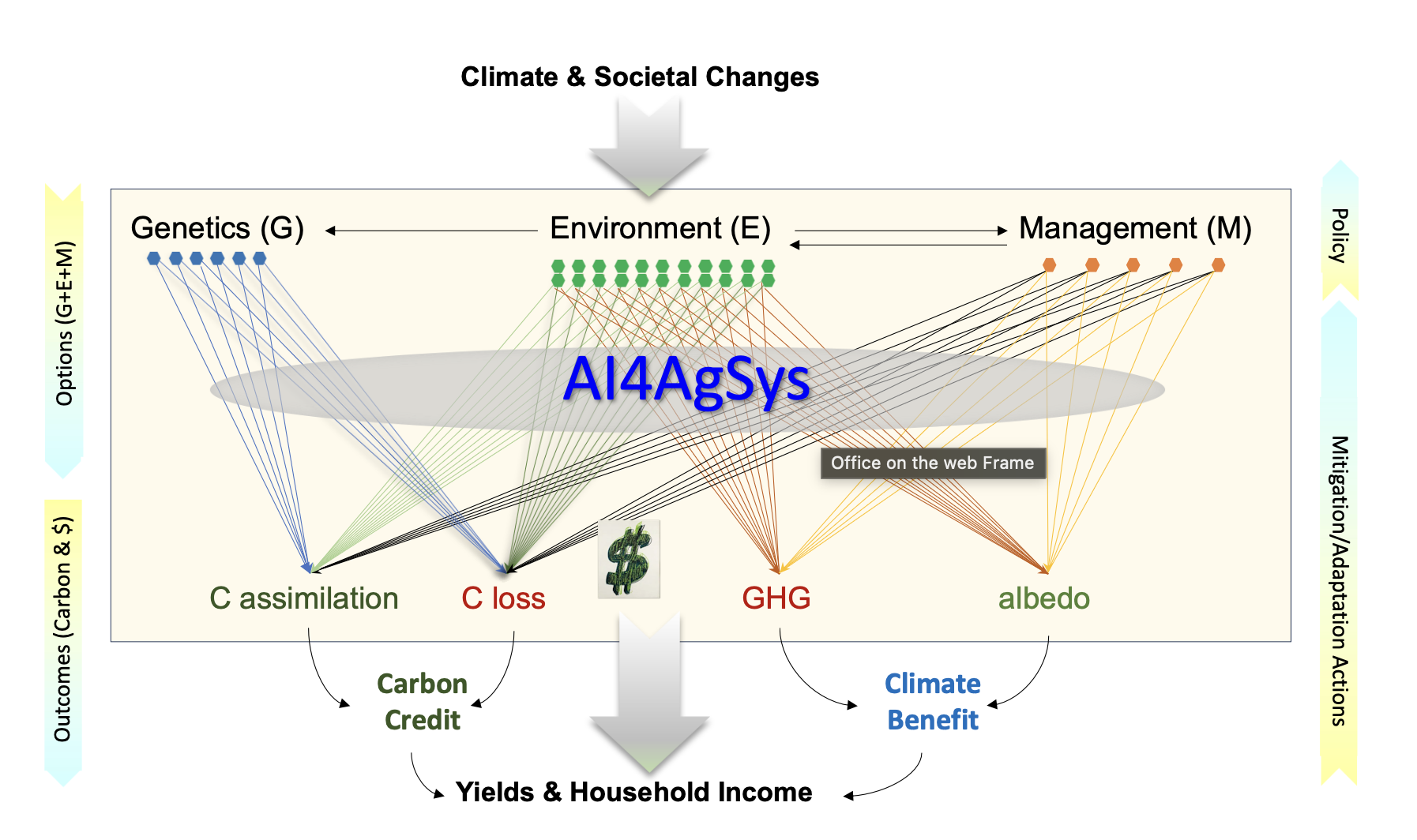
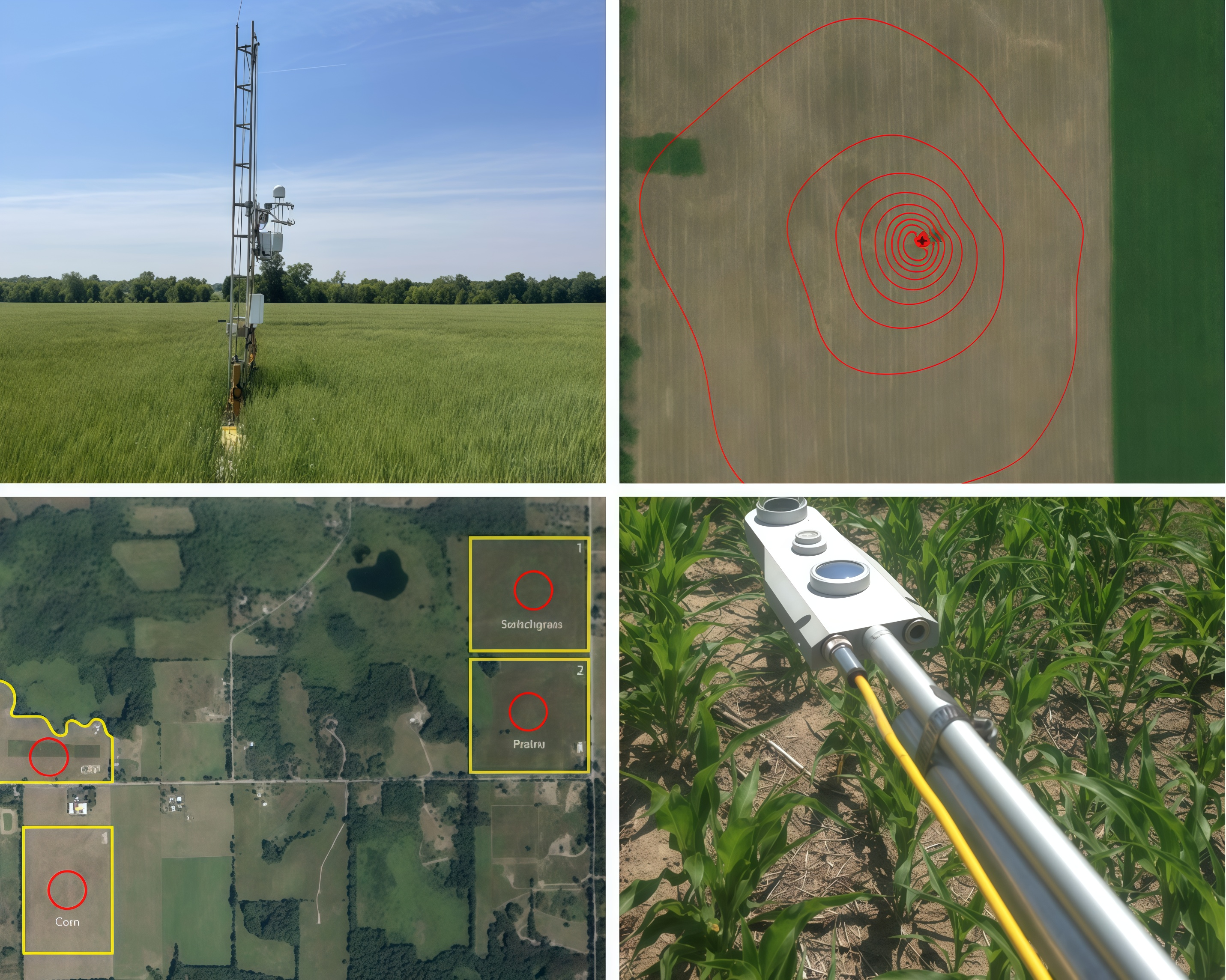
Research Projects


Climate, Land, & (Health) Outcome of Dengue Fever (CLOUD): A national level analysis of Peru
NASA Interdiciplinary Science (IDS) (2024-2028)

PIs: Peilei Fan, Jiquan Chen, Furqan Irfan, Ruben Briceno

Dengue virus (DENV), the causative pathogen of dengue fever, is one of the most widely spread mosquito-borne viral diseases, together with Japanese encephalitis, malaria, filariasis, and yellow fever. Since the earliest recorded outbreak in 1779, dengue fever has become a global problem, and it is endemic in 129 countries, with the American, Southeast Asian, and Western Pacific regions most seriously affected. Our overall objective of this project is to predict and develop adaptive and mitigative plans for future dengue outbreaks under future climate, LCLUC, and human development based on the interdependent relationships among incidence of dengue fever, vector density, and various risk factors identified through our research, with an emphasis on environmental justice and policy adaptation. To achieve this objective, a conceptual framework is proposed to articulate four major aspects: (1) natural/climate and human (socioeconomic dynamics) forcing mechanisms, (2) vulnerability that includes the three dimensions of exposure, sensitivity, and adaptive capacity, (3) public health impact assessment, and (4) strategic adaptations and mitigation to improve environmental justice.

Decoding Land Transitions across the Urban-Rural Continuums (URC): A Synthesis Study of Patterns, Drivers, and Socio-environmental Impacts in Southeast Asia (Peilei Fan, Jiquan Chen, Atul Jain, Soe W. Myint , Jiaguo Qi, Karen Seto)

Southeast Asia (SEA) has emerged as a hotspot in global climate change, land cover and land use change (LCLUC), geopolitical conflicts, and societal changes since the end of World War II. As a result of systematic efforts of the NASA LCLUC Program since the early 2000s, massive amounts of data, remote sensing images, and other geospatial products have been collected, substantial human resources and research networks have been built, many tools and models have been developed, and significant knowledge has been gained in the region.. In this proposal, we established an interdisciplinary team of active scholars within the SARI Program to bring relevant efforts, with LCLUC projects as the core, toward a synthesis of data, tools, models, and knowledge so that our previous research can be used to generate more value to the scientific community and society. We propose to focus on the urban-rural continuums (URC) – an innovative concept adopted by this team – as our primary domain of synthesis. Nineteen URCs of cities of various sizes from 8 SEA countries have been selected for detailed analyses at the local level. Our synthesis effort will be guided by the research questions examine/quantify drivers, patterns and processes of land use transformation across the URC.

Cross-Lab Incitive for Urban-Rural Continuums (URCs) along the Silk Roads

Silk Roads, a major human infrastructure connecting Europe with East Asia, played important role in promoting human civilization and society formation. Among the many routes, the 14800 km long one that rans from the Mediterranean coast to Xian in western China is the core. Over 560 modern cities fall in a 100-km buffer zone (2.79 million km2), including nine capital cities of the 11 countries. Some of these cities have long history, being established prior to the Silk Roads. For example, Baghdad was one of the earliest societies before Persian empires, and Xian in China and Tehran in Iran served as the bases of major empires. Geographically, these routes were shaped by avoiding major deserts (e.g., the Karakum Desert) and glacier mountains (e.g., the Tianshan), allowing for minimal exposures to climate extremes and easier access to water that in other parts of the Asian Drylands Belt (ADB). In this study, we examined these cities through the lens of urban-rural continuum (URC). Multiple social-environmental conditions along eight directions from the urban center to rural landscapes were explored for anisotropic changes, their interdependencies, and the spatial aggregations of the URC in different parts of the Silk Roads. As expected, four clusters are seen on the Mediterranean’s east bank, the south bank of the Caspian Sea to the Tigris River, Toshkent to the west slope of Tianshan, and the west of Xian. Waterways play a critical role in the anisotropic features of URC, with the geomorphic features further modulating the changing rate and divergencies among and within URCs. Although these cities are located in different countries and have diverse cultural backgrounds, their lasting and recent growth (population and GDP per capita) appear to be highly correlated with current temperature and precipitation, vegetation (leaf area, GPP), soil moisture, and rich water resources.

Key Curriculums for Ecology and Environmental Sciences in Kazakhstan and Central Asia Academic Institutions

The goal of this project is to share and revise the curriculums of major courses required for ecological and environmental sciences for several institutions of higher education in Kazakhstan. Colleges are especially critical at this stage in the development of state-of-art curriculums in ecology and environmental science for Kazakhstan because the nation is gearing up to implement new strategies in natural resource management, including many initiatives related to agriculture, rangelands, and water resources. Both the new policies and their implementation rely on the knowledge and skills of new generations. The partnership project is supported and funded by the U.S. Embassy in Kazakhstan and implemented by American Councils for International Education.

Interdependent dynamics of food, energy and water in Kazakhstan and Mongolia: Connecting LCLUC to the transitional socioecological systems

The overall objective of this study is to examine the interconnectivity of food, energy and water (FEW), as well as their interdependent dynamics following rapid changes in climate, population, economy and institutions that have intensified land use in Kazakhstan (KaZ) and Mongolia (MG). Our working hypothesis is that the interconnections and interdependencies of FEW measures vary significantly between KaZ and MG, among the regions within each country, and among herding landscapes. we challenged ourselves with three pressing questions: How have the FEW functions been affected by the independent and interactive forcings of biophysical and socioeconomic changes in water-limited KaZ and MG? What are the causes, regulatory mechanisms, and functional consequences of the FEW nexus at local, regional, and national levels? What are the roles of LCLUC in understanding the complex relationships between the causes and consequences of the FEW nexus at different spatial scales?

Coupled Human & Natural Systems on the Mongolian Plateau

The Mongolian Plateau, divided by similar ecosystems yet contrasting socioeconomic systems known as Mongolia and Inner Mongolia, is home to rapid biophysical and socioeconomic changes. The purpose of this study is to bring together a multidisciplinary research team to examine and model the changes of the natural and human systems on the Plateau as well as the critical feedbacks between them over recent decades. This is the lab's third funded project investigating the Mongolian Plateau.

Socioecological Carbon Production in Managed
Agricultural-Forest Landscapes (ISEC)

Land use, land cover changes, and ecosystem-specific management practices are increasingly recognized for their roles in mediating the climatic effects on ecosystem structure and function. As demonstrated by some scholars, human activities can influence C fluxes and storage far more than climatic changes. All of these activities require a CO2-equivalent amount of energy ("social C flux") to offset the actual amount of C sequestered by the ecosystems and landscapes. A complete life cycle assessment (LCA) is needed to account for the actual sequestration strength at different spatial and temporal scales.

Urbanization and sustainability under global change and transitional economies: Synthesis from Southeast, East and North Asia (SENA)

Transitional economies in Southeast, East, and North Asia (SENA), including Cambodia, Laos PDR, Myanmar, Vietnam, China, Mongolia, and the Asian part of Russia (Siberia), have experienced liberalization, macroeconomic stabilization, restructuring and privatization, and legal and institutional reforms over the past three decades. Building upon our previous research, rich databases, and diverse expertise, we set our objective toward synthesizing the data and knowledge on urban sustainability to the socioeconomic transformation and changing climate in transitional economies in SENA.

Sustainability Assessment of the
New Technology and Products of PV Systems (SEP)

Solar photovoltaic electricity technology is considered one of the top choices to meet the future's need for CO2-free sources. It must be made sustainable from economic, environmental, and societal perspectives. Our objective is to develop the concepts, materials, and processes necessary to economically produce environmentally friendly thin-film solar cells from earth-abundant, environmentally benign (EAEB) materials. We have assembled a multi-disciplinary team representing physics, materials science, engineering, chemistry, socioeconomics, environmental science, and education to address these complex issues.

Ecosystem-Society Interactions on a Changing Mongolian Plateau

The overall objective of this project is to synthesize our data, knowledge, and quantitative models on ecosystem and social resilience to the changing climate and dynamic socioeconomic pressures placed on the fragile, Mongolian ecosystems. This will be done by modeling natural system (NS) and human system (HS) processes and dynamics as well as the interactions and feedbacks among them. We will use multiple data sources to document human and natural dynamics at multiple temporal and spatial scales for the Plateau, where Inner Mongolia and Mongolia have had similar climates, ecosystems, cultures, and traditions, but different governments, land uses, economic development, and demographic changes in the past.

Bioenenergy at the Great Lakes Bioenergy Research Center

In this project, we use the eddy covariance (EC) method as our primary tool in making intensive, continuous measurements of NEP, water loss through evapotranspiration (ET) and energy balance at the six KBS-GLBRC “Scale-Up Fields”: switch grass, restored prairie and continuous corn fields (two replicates of each system).

We hypothesize that significant differences exist in ecosystem production, biophysical regulations and below-ground carbon allocation among the three biofuel production systems.  These differences are clearly reflected at multiple temporal scales.  

US-China Carbon Consortium (USCCC)

The USCCC mission is to facilitate better understanding of the environmental factors influencing the rate and magnitude of carbon sequestration and water cycling across a range of ecosystems and climates using mutually agreed upon measurement protocols and equipment, and through a collaborated network of data sharing and analysis.

Initiative