

AI-Based Forecasting for Resilient Agriculture
Machine learning · Remote sensing · Michigan agriculture
Introduction
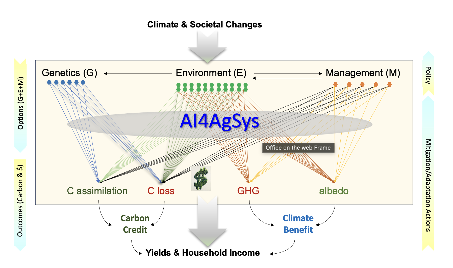
Developing effective adaptation and mitigation strategies is both urgent and necessary for farmers — our primary clients. We have assembled a diverse group from four colleges to co-develop AI4AgSys, an AI-based forecasting system for four major agricultural production systems in Michigan: corn, soybean, wheat, and potatoes.
AI4AgSys is a large-scale, pre-trained deep learning forecasting system trained with massive, diverse datasets using self-supervised and multi-task learning techniques — where the system learns by predicting parts of the data from other parts, reducing the need for extensive labeled data. It integrates machine learning, remote sensing, and field data, synthesizing satellite imagery, weather station data, crop model outputs, and historical yield records to generate near-real-time and seasonal forecasts of crop productivity and climate risk.
By making AI-driven insights actionable at the farm level, AI4AgSys supports more resilient and sustainable food production in the face of increasing climate variability across the Great Lakes region.
Data
Data Categories and Descriptions
- AI4AgSys Forecast Products Michigan agricultural yield and climate risk forecasts derived from the AI4AgSys modeling system, integrating satellite imagery, crop models, and machine learning.
- Geospatial & RS Database This integrated repository contains over 28,000 distinct data layers spanning five critical themes, including physical environment and soils, land use and crop distribution, moisture and climate stress, biomass and yield indicators, and remote sensing imagery. These layers have multiple spatial resolutions, from field-scale (10–30 m) to regional-scale (up to 1 km).
- Long-Term Analysis of Record Calibration (AORC) AORC is an hourly meteorological forcing dataset, a retrospective gridded product produced by NOAA’s Office of Water Prediction. This include 246 daily station sites and 28 hourly station sites of 1971-2025 for our study region. The Enviroweather daily and hourly data sets have 103 station series site records back to 1997
- Socioeconomic Statistics Data from multiple sources (e.g., NASS) are compiled at farm, county and regional levels.
- Social Surveys of the Farmers Dozens of farmers responded to our household surveys annually. The survey data cannot be shared at site level (IRB protocols)
- Ecosystem Flux Towers and Data Direct measurements of net ecosystem exchange (NEE) of CO₂, CH₄, H₂O, and energy are available at 30-minute intervals, along with ancillary microclimate data, from two GLBRC sites (2009–present), LTAR (2024–present), and AI4AgSys (2025–present).
- In Situ Microclimate Microclimatic monitoring has been conducted at six croplands at 30 min intervals in southern Michigan since summer 2025.
- Remote Sensing Training Datasets Multi-year Landsat and Sentinel-2 composites for Michigan croplands, labeled with ground-truth yield records for model training and validation.
- Site Specific Images Images and photographs of the study sites are available in shapefile and JPEG formats. [View Gallery]
For data access and collaboration inquiries, contact Dr. Jiquan Chen.
Team

Jiquan Chen
Professor & PI

Kurt Thelen
Professor & COI

Jiliang Tang
Professor & COI

Christine Charles
Extension Educator & COI

Dennis Pennington
Wheat Systems Specialist & COI

Molly Sears
Assistant Professor & COI

Jeffrey A. Andresen
Professor & COI

Sandy Marquart-Pyatt
Professor & COI

Jie Dai
Research Associate

Cheyenne Lei
Research Associate

Dileepa Jayawardena
Research Associate
Jin Wang
Research Associate

Joseph Seitz
Research Associate
Moriz Steiner
PhD Student

Connor Crank
PhD Student

Nurul Mujahid
PhD Student

Zhenhai Liu
Visiting PhD Student

Jay Revolinsky
PhD Student

Xinnan Dai
PhD Student

Yue Wang
PhD Student

Taiji Zhou
Research Assistant
Publications
Survey
The AI4AgSys survey invites Michigan farmers to share property, crop, and management information that supports forecast development and on-farm collaboration. Use the link below to open the questionnaire.
Contact
Principal Investigator
Dr. Jiquan Chen
Department of Geography, Environment & Spatial Sciences
Michigan State University, East Lansing, MI 48824
Email: jqchen@msu.edu
Phone: (517) 884-1884
Google Scholar: Profile

