
The Lake Erie Center Sensor Network
Landscape Ecology and Ecological Science | LEES Lab
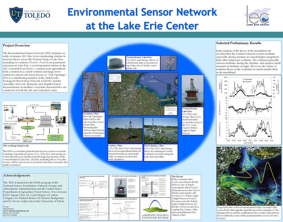
Project Overview
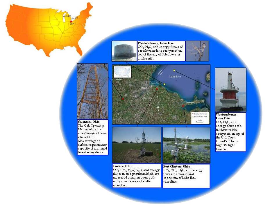
Carbon and water budgets of large freshwater lakes include four major processes: precipitation, flows between the land and lake (river and shorelines), deposition and decomposition at the lake bottom, and gas exchanges between the lake surface and the atmosphere. Within the lake, biotic processes (e.g., photosynthesis and respiration) that are influenced by chemical and physical properties play direct roles in the above four major fluxes (i.e., the underlying processes). With our advantageous location and facilities at the Lake Erie Center (LEC), we have established the essential infrastructure to measure the exchange of CO2 and H2O between the lake surface and the atmosphere, as well as the key ancillary ecosystem parameters (e.g., microclimate and water properties) to begin our endeavors of mechanistic explorations of Lake Erie. The Lake Erie Sensor Network (LESN) includes a total six eddy covariance (EC) flux tower monitoring stations to measure fluxes across the Western basin of Lake Erie, including two stations (PermS1, PermS2) on permanent structures in Lake Erie, a vessel-mounted station on the LEC's research boat (BoatS), a station in an agricultural field, a station in a coastal wetland and large tower station in a mixed oak forest known as "Oak Openings". The LESN is a contributing member of the Global Lake Ecological Observatory Network (GLEON) and the Ameriflux Network. Biometric and chamber based measurements of ancillary ecosystem characteristics are conducted at both the site and watershed scales.
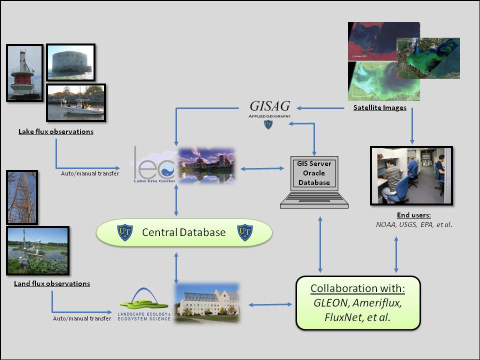
The LESN is a real-time platform that focuses on net ecosystem exchange of greenhouse gases (CO2, CH4, H2O, and energy) as well as the physical, chemical and biological properties of the western basin of Lake Erie. All data, including those of six flux towers, will be open access to promote education, research, and public awareness.
Updates
Progress Updates from the Lake Erie Center Sensor Network
18 July, 2011
The Toledo water intake tower preparation is coming along nicely. We have secured permission to use the existing sensor pole on the intake for mounting sensors and the crew from the City successfully removed the decommissioned Coast Guard equipment from this sensor pole last week. Mike has been working in the machine shop with Butch Burger to build a custom aluminum frame and structure to properly mount the solar panels that will charge the EC system batteries on the intake crib. We will be recycling some structural aluminum components from the Coast Guard's solar panel system. Depending on the weather I may be making a trip this week with the crew from the city to begin repairs to the the existing structure we will be using.
The team has been unsuccessful in getting to the Light #2 Coast Guard light beacon and the site of the 2nd flux tower on Lake Erie. A trip was attempted on Friday with Steve Ruburg and his crew from NOAA. The wind and weather forecast was better than every other day last week. However, we took off in the morning from Bolles Harbor near Monroe and unfortunately had to turn around before reaching the light beacon due to heavy wave action with winds coming out of the Northeast.
There are additional tasks Mike has been working on to move the project forward. The instrumentation for the two structure-mounted flux towers is currently being tested in the LEES lab and Mike has been working to customize the data logger program for each site. Mike has ordered a field laptop for use on the project that will provide a reliable connection to the data loggers in the field and the ability to upgrade to a broadband internet connection in the future for wireless internet access during field campaigns.
18 August, 2011
A quick update from the P.I. meeting today on 18 August 2011
1) The first item was an update on the status of the two permanent EC flux towers. The intake crib should be up and running by next week (weather dependent). The infrastructure is in place; the power system will be installed tomorrow; and the sensor mounting will take place next week. Approval from the U.S. Coast Guard is pending for installation of the EC flux system on Light #2. Plans were sent on August 1st. It was also requested to be granted unlimited access to the Light tower allowing for the possibility to complete trips using the LEC boat making installation less dependent on 3rd parties. Both towers should be up and running for most of September and October which will give us some data to work with this winter. The two towers with the "above water" sensors will remain in place throughout the winter.
2) A few other issues relating to winter work and site access were discussed. The water intake crib will be inaccessible for the first part of winter. It is possible that once the lake is frozen solid we will be able to access the crib using the LEES lab snow machine. Steve Ruberg from NOAA will be contacted to discuss winter access at the Light #2 tower site. Additionally, Mike will be working with technicians from Campbell Scientific to design a wireless data access system for the towers using radio frequencies. This will eventually be integrated to real time data available online and archived to the server.
3) Dr. Chen and Mike will be working to develop a Webpage for the Sensor project. Items to be included will be; a timetable with monthly reports and updates; pictures and diagrams of the tower sites; posters and presentations from the project; and eventually the real time data links.
4) The next meeting with all Sensor project P.I.s will be sometime late this Fall. Mike will send out an email when the time gets near.
30 September, 2011
Installation of the flux station at the water intake crib was completed on September 1st. Everything is running fine and the unprocessed data looks good. We will continue to monitor the status and will most likely begin processing the raw data in the next few weeks.
The station at the Toledo Light #2 tower has encountered many challenges. The instrumentation has been tested in the lab and is ready to go. The challenge involves loading equipment to a very narrow step on the tower in open and choppy water. I've made multiple trips with the group from NOAA and the LEC boat only to turn around for fear of damaging a vessel or risking injury. The new plan is to invest in a one-time fee, paid to the Meinke Marina crew to charter a steel-haul boat and a captain to take myself and the equipment to the tower. We have scheduled this for Monday (10/3) weather permitting. This will guarantee a safe and successful trip to unload and install the tower. After installation we can return to the tower using the LEC boat or join the NOAA group to download data.
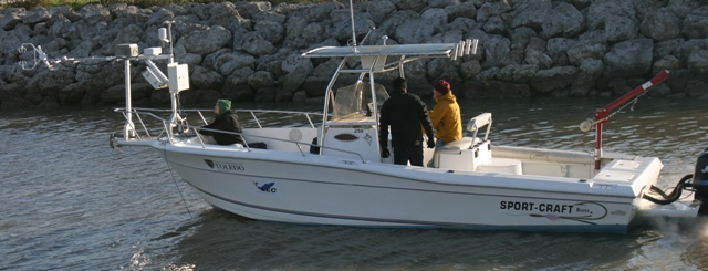
The structure for the vessel mounted flux station is being constructed with the help of Butch Berger. I am pleased to say that we will be able to mount the station on the front of the LEC boat without drilling any additional holes or hardware. We will use existing hardware and still have full functionality of the anchor. The structure is completely custom designed and can be removed easily after the completion of field campaigns. The goal is to complete the installation soon and have a very quick test run to collect some "test" data to work with this winter.
In the next two weeks we will begin testing for radio connectivity between the lake stations and the LEC. This is the first step in have a completely wireless connection and data retrieval method. This will reduce the issue of access to the towers and allow us to require very infrequent visits to the sites for maintenance.
1 November, 2011
We have successfully completed the very first mission with the vessel mounted, mobile flux station (MoFS). The weather was great this morning and we were able to collect some valuable data. This will give us some initial data to see that the system works properly and help with developing improvements for subsequent trips next year. I owe a huge Thanks to Peter Bichier, Ranjeet John and Butch Berger for their help with getting this up and running. Every structural part of the station was custom designed and constructed from aluminum stock. We were able to mount the station on the MayFlier #2 using only existing hardware. The data set from the MoFS campaigns will give us and an understanding of spatial CO2 fluxes and "connect the dots" between the two fixed Lake Erie Flux towers.
Both permanent flux stations are running well and initial data exploration looks promising. This winter a large amount of my time will be spent processing the raw data from the stations and developing some figures to explain the Lake fluxes. In order to save space on the flux station memory cards I will be modifying the programs on the data loggers for winter. This will allow for continuous data collection until spring when we can return to the stations.
Additionally, a draft of the project website is nearly finished and we should have access to the new server with around 20 TB of storage space later this week. This will make all documents, photos, raw data and eventually real time data available from anywhere!
21 February 2012
Over the winter there have been major accomplishments with the Lake Erie Center Sensor Network (LECSN). The LECSN website is up and running and quickly accessible from the LEC and LEES lab websites. Preliminary data is available on the website and the formatting will allow for quick upload of winter data collected this spring.
The mobile flux station (MOFS) has been modified and I have resolved some of the issues with the data logger program and the hardware. It is ready for the first field campaign in March. The route for the MOFS has been prepared and includes measurements in the Northern part of the Western basin. Concessions with the Canadian coast guard will be made before sampling in Canadian water.
The data logger programs at the two permanent stations were simplified to run continuously over winter. The stations are storing the half hour mean flux data in order to save data space. By next winter we will be remotely connected to the stations and have the capacity to collect high speed flux data and remotely download. The programs have been modified further this winter to fix a few issues noticed in last year’s data.
The equipment for remote connectivity has been purchased using the sensor grant and I am currently working with Tom Hodges to prepare a plan to mount the antenna on the LEC communication tower.
The YSI water quality sonde will be mounted at the water intake crib this spring and remain for the entire field season. I have designed a custom housing to suspend and protect the sonde inside the crib. It will be mounted with the Turner CDOM probe and wired to the data logger to combine with the flux data. Currently I am working to combine the flux program and program for the YSI sonde.
31 January, 2013
An update from the P.I. meeting today on 31 January 2013
1) The mission in this year will focus on previous and new data process and report, proposal summary and paper writing. Will prepare new research projects based on the environmental sensor network (ENS).
2) New post doctor Changliang Shao reported some advance from 1 January, PPT named”Flux data process and work plan”, including three parts, (1) Overview of others eddy covariance studies over lake surfaces, (2) Data process and preliminary results, (3) 2013 work plan.
3) Crib and Light towers maintaining, plan to add net radiation and water heat storage (layers temperature) sensors. The YSI water quality sonde will be mounted at the water intake crib this spring and remain for the entire field season after combined the flux program and program for the YSI sonde. Mobile tower sampling will be once per month intensive field campaigns providing spatial flux data from May after the boat maintained.
4) The next meeting with all Sensor project P.I.s will be sometime late this Fall. Shao will send out an email when the time gets near.
14 October, 2013
BO Room2005
1) PIs talked about the data sharing plan. Tom will share the biological data.
2) On 12 October, Changliang and Xuefen Yu went to the light site to change a calibrated (Mobile) LI-7500. The door is locked. It spent some time to contact the NOAA to get the locker pin. For fear of damaging a vessel or risking injury, Jiquan and LEC invest in a one-time fee, paid to the Meinke Marina crew to charter the LEC boat.
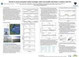
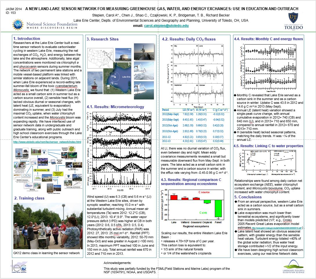
3) ) I reported some new results, including the daily, monthly and yearly data. From an annual perspective, the lake acted as a carbon source of 70.8 and 116.1 g C m-2 yr-1 in the first and second year, respectively, but a small carbon sink in summer in the both years.
4) ) I will prepare a poster for the AGU falling meeting to report our advances.
Support
The Lake Erie Sensor Network is funded by the Biological Field Stations and Marine Laboratories (FSML) program under the National Science Foundation. It is overseen by a group of researchers from the Michigan State Universty's Department of Geography, University of Toledo's Department of Environmental Sciences and the Lake Erie Center. The Principal investigators include Dr. Jiquan Chen, Dr. Carol Stepien, Dr. Johan Gottgens, Dr. Richard Becker, Dr. Thomas Bridgeman, and Dr. Kevin Czajkowski. The project employs one full time technician Michael Deal.


Team Members
Name |
Role |
Contacts |
|---|---|---|
| Carol A. Stepien | Principal Investigator | carol.stepien@utoledo.edu |
| Richard H. Becker | Co- Principal Investigator | richard.becker@utoledo.edu |
| Thomas B. Bridgeman | Co- Principal Investigator | thomas.bridgeman@utoledo.edu |
| Jiquan Chen | Co- Principal Investigator | jqchen@msu.edu |
| Kevin P. Czajkowski | Co- Principal Investigator | kczajko@utnet.utoledo.edu |
| Michael W. Deal | Sensor Technician | michael.deal@utoledo.edu |
| Changliang Shao | Research Associate | clshao@msu.edu |
Designs
A) Sensor position
on top of the City of Toledo water intake crib
(PermS2, photo)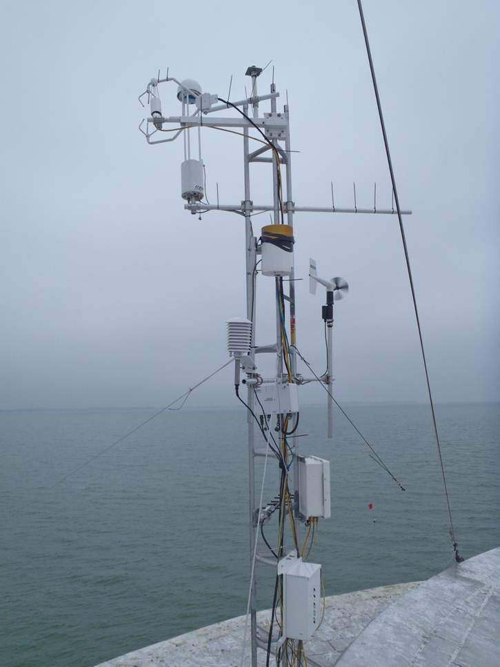 B) Sensor position on top of the City of Toledo water intake crib (PermS2) 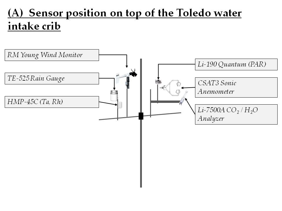 C) Hardware for mounting sensor bar on top of the City of Toledo water intake crib (PermS2)  D) Location of Sensors on top of the Toledo Light #2 light beacon (PermS1) 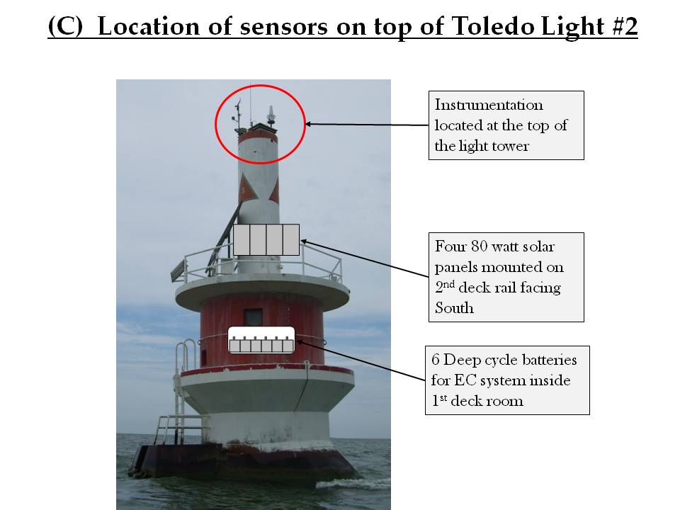 E) Sensor Position on top of the Toledo Light #2 light beacon (PermS1)  F) Sensor layout for Marshland and Cropland stations 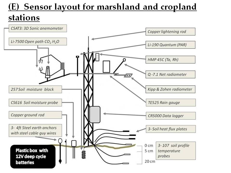 G) Mobile Flux Station sensor position (MoFS)  |
Site Locations for the Lake Erie Center Sensor Network
Mobile Flux Station (MoFS)
Proposed route for the vessel-mounted eddy covariance flux station (MoFS) mounted on the bow of the Mayflier research vessel through the algal bloom near the estuarine of the Maumee River and the sedimentary flow south of the Detroit River and within the route of the permanent flux stations in the Western basin of Lake Erie. Nine sampling locations were selected within the Western basin for complete spatial coverage of flux and water quality monitoring.

Methods
Micrometeorological parameters and instrumentation measured on aquatic stations (PermS1, PermS2 and MoFS)
Sensor |
Manufacture |
Variable |
Frequency |
|---|---|---|---|
| CNR4 Net radiometer | Kipp & Zonen | Long and shortwave radiation | 20 sec - 30 min |
| HMP45C probe | Campbell Scientific | Air temperature and relative humidity | 20 sec - 30 min |
| 107 Temperature probe | Campbell Scientific | Water temperature profile | 20 sec - 30 min |
| 5305 Wind monitor | R.M. Young | Wind speed and direction | 20 sec - 30 min |
| Li190SB Quantum sensor | Li-Cor | Photosynthetically active radiation | 20 sec - 30 min |
| TE525 Rain gauge | Texas Electronics | Precipitation | 20 sec - 30 min |
| IRR-P Infrared thermometer | Campbell Scientific | Water surface temperature | 20 sec - 30 min |
Micrometeorological parameters and instrumentation measured on terrestrial stations (Cropland, Marshland and Oak Openings)
Sensor |
Manufacture |
Variable |
Frequency |
|---|---|---|---|
| CNR4 Net radiometer | Kipp & Zonen | Long and shortwave radiation | 20 sec - 30 min |
| Q-7.1 Net radiometer | Campbell Scientific | Net radiation | 20 sec - 30 min |
| HMP45C probe | Campbell Scientific | Air temperature and relative humidity | 20 sec - 30 min |
| 107 Temperature probe | Campbell Scientific | Water temperature profile | 20 sec - 30 min |
| 5305 Wind monitor | R.M. Young | Wind speed and direction | 20 sec - 30 min |
| Li190SB Quantum sensor | Li-Cor | Photosynthetically active radiation | 20 sec - 30 min |
| TE525 Rain gauge | Texas Electronics | Precipitation | 20 sec - 30 min |
| HFT Soil heat flux plates | Campbell Scientific | Soil heat flux | 20 sec - 30 min |
| CS616 Soil moisture probe | Campbell Scientific | Soil moisture | 20 sec - 30 min |
| CS257 Soil moisture block | Campbell Scientific | Soil Moisture | 20 sec - 30 min |
Instrumentation for the measurement of turbulent exchange of carbon dioxide and water vapor between the water surface or vegetative canopy and the atmosphere
Sensor |
Manufacture |
Variable |
Frequency |
|---|---|---|---|
| Li7500A IRGA | Li-Cor | Concentration of carbon dioxide and water | 10 Hz - 30 min |
| CSAT3 3-D Anemometer | Campbell Scientific | 3 dimensional wind vector | 10 Hz - 30 min |
| Li7700 Methane Analyzer | Li-Cor | Concentration of methane | 10 Hz - 30 min |
| NAV440440CA Inertial Sensor | Crossbow | Motion correction of fluxes | 10 Hz - 30 min |
| GPS Antennae | Crossbow | Spatial correction of fluxes | 10 Hz - 30 min |
Water quality measurement parameters and instrumentation
Sensor |
Manufacture |
Variable |
Frequency |
|---|---|---|---|
| 6600V2 Sonde | YSI | Temperature, conductivity, pH, dissolved oxygen, chlorophyll a, phycocyanin, turbidity, depth |
20 sec - 30 min |
| AC-S spectroradiometer | Wetlabs | Absorption spectra and backscatter measurements in Vis/NIR | 20 sec - 30 min |
References
Lake carbon and energy flux studies
Andersol et al. 1999. Estimating lake-atmosphere CO2 exchange
Blanken rt al. 2000. Eddy covariance measurements of evaporation from Great Slave Lake, Northwest Territories, Canada
Eugster et al. 2003. CO2 exchange between air and water in an Arctic Alaskan and midlatitude Swiss lake:Importance of convective mixing
Guerin et al. 2007. Significance of pelagic aerobic methane oxidation in the methane and carbon budget of a tropical reservoir
Liu et al. 2009. Eddy covariance measurements of surface energy budget and evaporation in a cool season over southern open water in Mississippi
Huotari et al. 2011. Long‐term direct CO2 flux measurements over a boreal lake:Five years of eddy covariance data
Jonsson et al. 2008. Gas transfer rate and CO2 flux between an unproductive lake and the atmosphere in northern Sweden
Morison et al. 2000. Very high productivity of the C4 aquatic grass Echinochloa polystachya in the Amazon floodplain confirmed by net ecosystem CO2 flux measurements
Nordbo et al. 2010. Long‐term energy flux measurements and energy balance over a small boreal lake using eddy covariance technique
Rouse et al. 2003. Interannual and Seasonal Variability of the Surface Energy Balance and Temperature of Central Great Slave Lake
Rouse et al. 2008. An Investigation of the Thermal and Energy Balance Regimes of Great Slave and Great Bear Lakes
Vesala et al. 2006. Eddy covariance measurements of carbon exchange and latent and sensible heat fluxes over a boreal lake for a full open-water period
Marine CO2 fluxes
Fredrickson et al. 2000. Naval Postgraduate School FLUX Buoy Data Report for the MUSE Deployment August - September 2000 Monterey Bay, California
Hare et al. 2004. Evaluation of the National Oceanic and Atmospheric Administration//Coupled-Ocean Atmospheric Response Experiment (NOAA//COARE) air-sea gas transfer parameterization using GasEx data
McGillis et al. 2001a. Direct covariance air-sea CO2 fluxes
McGillis et al. 2001b. Carbon dioxide flux techniques performed during GasEx-98
Smith et al. 1996. Handbook
Wanninkhof et al. 1999. A cubic relationship between air-sea CO2 exchange and wind speed
Biophysical processes of the Great Lakes
Verber et al. 1953. SURFACE WATER MOVEMENT, WESTERN LAKE ERIE
Data
Raw Data for the Lake Erie Center Sensor Network
In an effort to ensure a quality data product the LESN and LEC conform to federal and international standards, including the Federal Geographic Data Committee (FGDC). Metadata compliance is an ongoing effort guaranteeing maximum utility. As part of the GIS development, we standardize geographic data storage in geographic coordinates, facilitating easy incorporation with other projects. Adherence to the FGDC standards and ongoing implementation of additional standards , including the National Biological Information Infrastructure (NBII) interfaces our research projects with national and international research efforts.
Data Information
- PermS1 | Light Structure #2
- PermS2 | Water Intake Crib
- PermS3 | Mobile Data
Publication / Presentation
1) Shao, C, J. Chen, C. A. Stepien, H. Chu, T. B. Bridgeman, K. P. Czajkowski, R. Becker, Z. Ouyang, R. John. Diurnal to annual changes in carbon, latent and sensible heat over a Laurentian Great Lake, Journal of Geographic Research (under review).
2) Zutao Ouyang, Changliang Shao, Housen Chu, Richard Becker, Jiquan Chen, Thomas Bridgeman, Carol Stepien, Ranjeet John. Relating Chlorophyll-a to CO2 flux western Lake Erie, Ecological Applications (under review).
3) Ouyang, Z., J. Chen, R. Becker, H. Chu, J. Xie. Changliang Shao, Ranjeet John. 2014. Disentangling the confounding effects of PAR
and air temperature on net ecosystem exchange in time and scale. Ecological Complexity 19: 46-58.
4) Ouyang, Z., R. Becker, W. Shaver, and J. Chen. 2014. Evaluating the sensitivity of wetlands to climate change with remote sensing techniques. Hydrological Processes 28, 1703–1712 .
5) Chu, H., J. Chen, J. F. Gottgens, Z. Ouyang, R. John, K. Czajkowski, and R. Becker (2014a), Net ecosystem CH4 and CO2 exchanges in a Lake Erie coastal marsh and a nearby cropland, J. Geophys. Res., 119(5), 722-740.
6) Chu, H., J. F. Gottgens, J. Chen, G. Sun, A. R. Desai, Z. Ouyang, C. Shao, and K. Czajkowski (2014b), Climatic variability, hydrologic anomaly, and methane emission can turn productive freshwater marshes into net carbon sources, Global Change Biol., doi:10.1111/gcb.12760
Presentations from the Lake Erie Center Sensor Network
Project Overview Poster October 2011 (PDF)

Lake_erie_sensor_project_2012_presentation.pptx
Lake_erie_sensor_AGU_2013_presentation.pptx
Lake Erie Center board meeting 2014_Apr24_presentation.pptx
Joint Aquatic Sciences Meeting_poster_May18-23,2014.pptx
Contact
Center for Global Change and Earth Observations (CGCEO)
202 Manly Miles Bldg. 1405 S. Harrison Rd,
Michigan State University,
East Lansing, MI 48823