Landscape Ecology & Ecosystem Science Lab
Digital Agriculture and Flood Mapping for Kazakhstan's Changing Climate
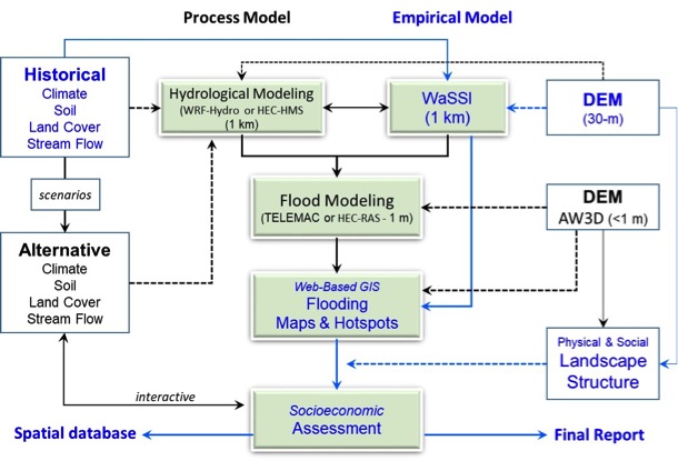
Flooding zones can be delineated from stream flow and elevation. While digital elevation models (DEMs) are available, our primary challenge is to predict stream flows (i.e., frequency, magnitude, and duration of peak flows) that depend on three key conditions: precipitation, glacier melting, and land use and cover (LUC). With geospatial statistics of population, agriculture, and economic statistics, we can assess the historical impact through an empirical WaSSI, or a hydrologically process model to map flooding zones and high-risk zones. Through collaborations between researchers at Michigan State University and Kazakhstan institutes and agencies, this demo project is designed to geospatially map the flooding and affected zones along two watershed in Kazakhstan. Specifically, we will first construct accurate spatial maps of historical flooding zones based on remote sensing images and DEMs and to develop an empirical Water Supply Stress Index Model (WaSSI) based on historical climate, vegetation, soils, and stream flow. We then will assess the social and economic consequences by integrating the flooding zones and the landscape structure. The output from the models will be combined with geospatial socioeconomic data, including demographics, economic activities (including agricultural activities, industries, and commercial activities), and social resilience, to develop a flooding vulnerability index for the DEMO watersheds. Three outcomes of this project are:
1) A web-based GIS page showing the affected zones and hotspots along the rivers;
2) A comprehensive database (physical, remote sensing, and socioeconomic) that can be shared with the stakeholders (e.g., different agencies), and
3) A final report identifying the effectiveness of our mapping approach, challenges and needs for the future efforts in other watersheds and at different spatial scales, and predictions of flooding under likely climate and land use scenarios.