Metadata for the Lake Erie Center Sensor Network
In an effort to ensure a quality data product the LESN and LEC
conform to federal and international standards, including the Federal Geographic
Data Committee (FGDC). Metadata compliance is an ongoing effort guaranteeing
maximum utility. As part of the GIS development, we standardize geographic data
storage in geographic coordinates, facilitating easy incorporation with other
projects. Adherence to the FGDC standards and ongoing implementation of
additional standards , including the National Biological Information
Infrastructure (NBII) interfaces our research projects with national and
international research efforts.
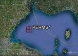
PermS1 (Light Structure #2)
Metadata Report
|
Project:
|
Lake Erie Center
Sensor Network
|
|
Funding Source:
|
NSF Field Station and
Marine Laboratories
|
|
Investigators:
|
Jiquan Chen
Michael W. Deal
Carol Stepien
|
|
Data Access:
|
Public
|
|
Data Set Location:
|
University of Toledo
Landscape Ecology and Ecosystem Science
Laboratory Server Toledo, Ohio 43606
419-530-2246
|
|
Data URL:
|
http://lees.geo.msu.edu/research/sensor_net.html
|
|
Site:
|
PermS1 (Light
Structure #2)
|
|
Location:
|
41.8314 -83.2006
|
|
Other Information:
|
Technician notes
available on web (READ_ME_PERMS1_NOTES)
|
30 Minute Mean Raw Data
DOWNLOAD
PermS1 (Light Structure #2)
Metadata Report
|
Project:
|
Lake
Erie Center Sensor Network
|
|
Funding
Source:
|
NSF
Field Station and Marine Laboratories
|
|
Investigators:
|
Jiquan
Chen
Michael
W. Deal
Carol
Stepien
|
|
Data
Access:
|
Public
|
|
Data
Set Location:
|
University of Toledo Landscape Ecology and
Ecosystem Science Laboratory Server Toledo, Ohio
43606 419-530-2246
|
|
Data
URL:
|
http://lees.geo.msu.edu/research/sensor_net.html
|
|
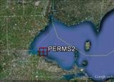
Site:
|
PermS2
(City of Toledo Water Intake Crib)
|
|
Location:
|
41.7167
-83.2667
|
|
Other
Information:
|
Technician notes available on web
(READ_ME_PERMS2_NOTES)
|
30 Minute Mean Raw Data
DOWNLOAD
MoFS (Mobile Flux Station)
Metadata Report
|
Project:
|
Lake Erie Center Sensor
Network
|
|
Funding
Source:
|
NSF Field Station and
Marine Laboratories
|
|
Investigators:
|
Jiquan Chen
Michael W. Deal
Zutao Ouyang
Peter Bichier
Carol Stepien
|
|
Data
Access:
|
Public
|
|
Data Set
Location:
|
University of Toledo
Landscape Ecology and Ecosystem Science
Laboratory Server Toledo, Ohio 43606
419-530-2246
|
|
Data
URL:
|
http://lees.geo.msu.edu/research/sensor_net.html
|
|
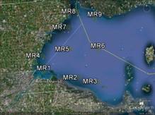
Site:
|
MoFS (Mobile flux station)
|
|
Locations:
|
|
MR1
|
41.721106, -83.39859
|
|
MR2
|
41.683169, -83.158264
|
|
MR3
|
41.654445, -83.023682
|
|
MR4
|
41.806125, -83.401337
|
|
MR5
|
41.8314, -83.2006
|
|
MR6
|
41.817385, -83.014755
|
|
MR7
|
41.945192, -83.210449
|
|
MR8
|
42.022773, -83.139038
|
|
MR9
|
41.979911, -83.023682
|
|
|
|
|
Other
Information:
|
Technician notes available
on web (READ_ME_MoFS_NOTES)
|
Parameters Associated with MoFS
DOWNLOAD